 English
 Ελληνικά


-
Fast facts
Population 2021: 355 inhabitants
Older Censuses 2011: 368, 2001: 520, 1991: 413, 1981: 410, 1940: 800, 1869: 639 inhabitants
Population density per Km² 25 inhabitants
Village altitude 220 m
Region averege altitude 230 m, mountainous
Village land area 0,05 km2
Region land area 14,1 km2
Parish Church 1 orthodox, agios Athanasios (saint Athanasios).
Economy relies mainly on agriculture (horticulture, viniculture, olive), during past times the main crop was tobacco.
-
Description
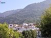
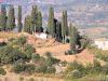
Idroussa village (Greek: Υδρούσσα), is located at the north of the island, at the northwest foothills of “Ambelos” mountain (or Karvounis), surrounded by vineyards and forests, with beautiful view to the plain of Karlovasi and to the sea. The distances are: from Samos town 33 km, from Karlovasi town 6,5 Km, from Pythagorio town 42 Km and from Marathokampos village 19 Km.
Administratively consists the local communities of Idroussa, which belongs to Karlovasi municipal unit, of West Samos Municipality with Karlovasi capital.
top-
History & name
The name of the village, originally was “Fourni” (= ovens), which probably originated from the ovens of the pottery (ceramic workshops), that existed until the 19th c. at the village. Em. Stamatiadis at his book Samiaka (1886), in addition to the aforementioned view, about the origin of the name, mentions a second, less probable version, according to which the name came from the place of the first settlers origin, which tradition says that came from the island of Fourni.
Victor Guerin, in his book description of the islands of Patmos and Samos (1856), in his attempt to find the location of the ancient city of Samos “Ipnousia” (Ιπνουσία), through the etymology of the name, places the location of the ancient city at the wider area of Idroussa, since Ipnos (Ιπνός) or Ipnous (Ιπνούς) means kiln or oven, in ancient Greek, and Ipnousia (Ιπνουσία) = place with many ovens, as well the origin of the old name, Fourni (= ovens), of the village. Guerin’s view is reinforced by the many ancient ruins that have been found from time to time in the surrounding area of Idroussa.
At the wider area of Idrousa, there was intense residential activity during the Byzantine period, as evidenced by the findings in the surrounding areas of the village, such as Christian tombs, water tanks, pottery and other ruins, probably of the Middle Byzantine and Late Byzantine Period.
Idroussa is one of the first villages of Samos, after the recolonization (1550), since it pre-existed in 1625, as it appears from a same year document, in which referred as “Fourni” (= old name of the village).
Around 1950, the village was renamed as “Idroussa” which derives from the ancient Greek words ύδωρ (~idor = water) and οὖσαν (~ousa = have), due to the many springs at the area.
top-
Tips
- The surrounding area has great archaeological interest, as evidenced by the ruins of antiquity and the Byzantine era.
- Visiting the church “Agios Athanasios and Cyril”, build at 1782 with remarkable frescoes
- Visiting the church “Kimisis tis Theotokou”, (=Assumption), build at 1663, located at the area “Petalouda”, also with remarkable frescoes.
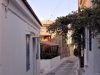
- Take a tour of the narrow alleys of the village and enjoy the beautiful architecture of the houses.
- The biggest social event of the village it’s the feast of “Agios Ioannis Baptists” at August 29, one of the largest in Samos.
- Follow the asphalt road to the north, to reach after 4 km Kontakeka village.
-
Video

