 English
 Ελληνικά


Fast facts
Population 2021: 143 inhabitants
Older Censuses 2011: 140, 2001: 204, 1991: 220, 1981: 284, 1961: 472, 1928: 635, 1886: 419 inhabitants.
Population density per km2 8 inhabitants
Village altitude 300 m
Region averege altitude 300 m, mountain
Village land area 0,03 km2
Region land area 17,5 km2
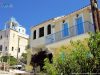
Parish church 1 orthodox, agios Georgios (Saint George). On August 10, 1886, a law was approved by the parliament of Hegemonic Samos for the construction of the church, while on July 4, 1887, a tax was imposed on salable timber to save financial resources for its construction.
Economy relies mainly on agriculture (olive oil, vegetables and some wine), beekeeping, logging, charcoal production and less on livestock (goats). During the 19th century, some silkworms and carobs were cultivated for animal feed.
Description
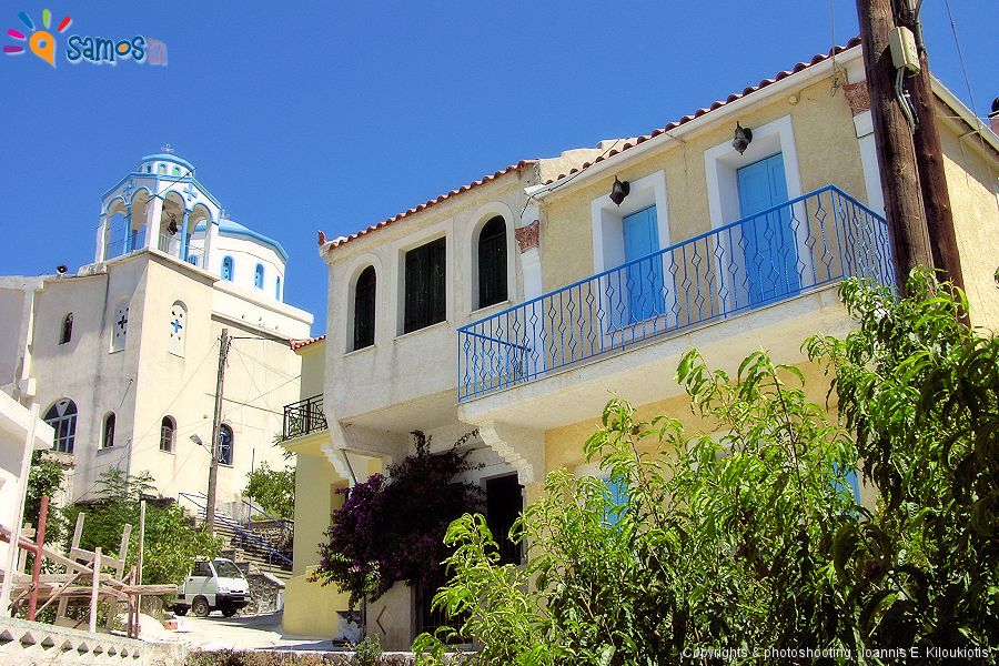
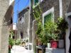
Kallithea village (Greek: Καλλιθέα) is located at the northwest foothills of Kerkis mountain and it’s the westernmost village of the island.
The distances are: from Samos town 64 km, from Karlovasi town 35 Km, from Pythagorio town 51 Km and from Marathokampos village 22 Km.
Administratively consists the local communities of Kallithea, which belongs to Marathokampos municipal unit, of West Samos Municipality with Karlovasi capital.
Kallithea and Drakei villages are the most remote villages of Samos and until 1965, when the road was made, they were completely isolated. This resulted to the economic and social dependence between the two villages and their parallel development. That’s why, in the memory of the Samians, these two villages are considered as one, as was reflected in the administrative division of the island during the period of the Hegemony in Samos (1834-1912), which constituted the Municipality of “Kalambaktasi”.
It’s built in a green landscape, with excellent view to the west, towards the Islands Fourni, Ikaria, Chios, sometimes Andros and you can also enjoy a spectacular sunset.
topHistory & name
The original name of the village was Prinias (= with many holm oaks), due to the holm oaks that grew in the area, ideal for charcoal.
During the period of Hegemony in Samos (1834-1912), Prinias (today’s Kallithea) together with the neighboring village of Drakei constituted one municipality named Kalambaktasi. After the unification of Samos with Greece (1912), they were divided in two different communities, where Kallithea maintaining the name Kalambaktasi, until 1958 when it took its current name.
There are various views for the origin of the name “Kalambaktasi”. Tournefortios claims that it comes from the alteration of “Katavevatis”, Em. Kritikidis that it comes from a Turkish word meaning “stone hat” while Ep. Stamatiadis, who writes it “Kalambakasi”, along with other interpretations, states that it probably comes from the city of Kalampaka in Thessaly, which probably was the place of origin of the first inhabitants. The opinion that fits best with the name, the location and the history of the area, is the second view of Stamatiadis, according to, the name came from a alteration of the Turkish words “kale bakış açısı”, which means “castle with a large view”.
The village was first inhabited probably around the beginning of the 18th c., since Georgirinis does not mention it, in the description of Samos of the 17th c. However, there was intense interest for the area, at least since the Early Byzantine period, because the strategic location allow the control of ship traffic in the straits of the islands of Samos, Fourni and Ikaria, through which cross the sea roads that connect the ports of southern Aegean with the Black Sea and the western Aegean with Asia Minor. There is no evidence of existence ancient city or village in the area, but it is certain of existed permanent guard to monitor the movement of ships, as evidenced by the ruins of the small tower at Pyrgaki area, archaeological finds in Agios Nikolaos (Ginaki) and other smaller watchtowers in the wider area.
During the period of Samos desolation (1476-1549), but also in periods that there was administration instability at the island, pirates must had the control of the area , since it was an ideal location for ships controlling and also a very good base to attack them. This view is reinforced by the occasional finding of buried treasures with gold coins in the wider area. Particular historical interest is the reference by Em. Kritikidis at his book Topography of Samos (1869) , for the finding of 80 gold Byzantine coins from the time of the emperor Justin II, 6th c AD.
The dozens of chapels in the area, testify that it was a place of isolation and contemplation for many orthodox Christians monks, from the 7th c, when monasticism began to develop at Samos. In the middle of the 15th century, at the southwestern areas of Kerkis mount, lived about 500 monks, out of 1,000 all over the island. They lived in huts, caves, but also in small monasteries (called Lavra), such as Panagia Makrini, Agios Charalambos (Zoodohos Pigi) and Agios Georgios, which were destroyed by Arabs Muslim attacks round to 890, and were re-established early of 10th c. with motivation by Saint Paul of Latros during the period that he was monk in Samos.
The construction of Agios Georgios parish church was decided by the Samian Hegemonic Parliament in 1886 by the law 376, while the costs for its reconstruction were covered by tax that imposed on timber marketable , as provided by the law 426 of 1887.
Ep. Stamatiadis, in his book Samiaka (1886) characterizes the inhabitants of the village as hardened, healthy and long-lived due to the fresh air, the cristal clear water and the large amount of rye and barley that they consume. In addition, mentions a romantic process of weddings in 18th and 19th c, according to this, the groom kidnapped the bride and they took refuge at the caves of Kerkis mount for a few days, then returned to the village for the official wedding.
topTips
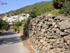
- To reach Drakei village, continue the asphalt road route to the north for 6.5 km.
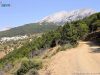
- Alternatively, follow the very beautiful dirt road route, from village cemetery, and after 11 Km you will find yourself in the village of Drakei.
>> At the 4th kilometer of the route you will find in a green environment the chapel of Agia Aikaterini (St. Catherine), built in 1462, by the monk Symeon Sinaitis and belonged to the Monastery of Sinai.
>> From the chapel of Agia Aikaterini, continuing the road to the south and after 850 m by car and another 420 m hiking you will find the cave and the chapel of Panagia Makrini.
>> From Panagia Makrini chapel, there is a hiking trail continues to “Vigla“, the top of Kerkis mount. CAUTION The trail is very difficult and dangerous and only for experienced climbers. To return from Vigla you can follow the same route or follow the path to Kampos Marathokampou, or the path to Memorial. - Follow the dirt route, just after Kallithea, which leads, after 3 Km, to Varsamos beach, after another 1.5 Km to the bay of Agios Isidoros, and continuing for another 4.3 Km you will find the village of Drakei.
- Enjoy the view and the sunset, from the place “501” just before the village.

